


14 Amazing Canoe Trips in Canada
By Mikaela Ferguson
Few things go together as perfectly as Canada and canoeing. Canada’s wilderness contains an unfathomable amount of water - some 3 million lakes and 8,500 rivers. Indigenous People built canoes to navigate the geography, later teaching European settlers, who used the canoe to expand across the country and trade.
Today, the canoe is still thriving, though now as a means of recreation, rather than for transportation or livelihood. A few canoe trips in Canada have garnered recognition across the country and internationally, making them a worthy addition to any adventurists’ bucket list.
In this post, I’d like to introduce you to some of the best canoe trips in Canada. This isn’t an exhaustive list - with so many lakes and rivers, it would be impossible to include all of the amazing places to canoe. I hope you find inspiration for your next trip!
Canoe Trips in Ontario
Algonquin Provincial Park
Algonquin is the quintessential destination for canoeing in Canada. With over 2,000 km of canoe routes, there is a seemingly endless list of possible canoe trips. The park is best known for its small and calm lakes, manicured campsites and the occasional moose spotting.
Getting to Algonquin
Part of Algonquin’s popularity is its proximity to two major Canadian cities. The distance between Toronto and Algonquin’s West Gate is a little over three hours, while the East Gate is within three hours of Ottawa. Connecting the two gates is Highway 60, a two lane highway which cuts directly through the south part of the park. The most popular access points, like Canoe Lake and Opeongo Lake, are adjacent to Highway 60.
Canoe Route Ideas
Burnt Island Lake - Burnt Island Lake is a stunning lake located a little north of Highway 60 and accessed from either Canoe Lake or Opeongo Lake. Due to its beauty and proximity to access points, Burnt Island Lake can be very popular, and as such, it can be difficult to secure reservations here.
Barron Canyon - Towering cliffs of red, white and black rock characterize the northeast edge of Algonquin. Don’t forget to plan a stopover at High Falls to explore a natural waterslide.
Tim River - The Tim River lies on the west side of Algonquin. You won’t find much, if any, current on the Tim River; its water gradually meanders toward the centre of the park where it eventually empties into the Petawawa River. The Tim River is best known for its wildlife spotting, especially in the spring and fall where moose sightings are very common.
Petawawa River - Algonquin is mostly a destination for flatwater canoeing, with an exception being the Petawawa River. The river originates at Ralph Bice Lake, in Algonquin’s north end, and flows to Lake McManus, at the east edge of the park. The river is punctuated by a series of swifts, Class I and Class II rapids and the occasional chute. It’s a thrilling ride for intermediate and experienced whitewater paddlers.

A view of The Natch on the Petawawa River, one of the best canoe trips in Canada.
Killarney Provincial Park + French River Provincial Park
The La Cloche Mountains are one of the most beautiful destinations in Ontario. Lying on the northern edge of Georgian Bay, the region is characterized by white quartzite mountains, pink granite and shimmering blue water. There are a few excellent provincial parks in the area, two of which are home to some of the best canoeing in Canada.
Getting to the French River
The French River starts at Lake Nipissing, near North Bay, and flows to Georgian Bay, directly south of Sudbury. Highway 69 passes over the river, and there are several access points on either side of the road.
French River Canoe Routes
Lake Nippising to Hartley Bay - To experience all that the French River has to offer, begin your journey at Lake Nipissing. There is a put in at Sucker Creek Landing, just off of Route 64. The first part of the journey is along the southern edge of Lake Nipissing, where you’ll paddle east and navigate between small islands while keeping the large expanse of Lake Nipissing to the north. After turning south and then southwest at Sandy Island, the French River picks up. As you paddle to Georgian Bay, you’ll go through gorges, a few rapids and eventually end at the French River Delta. The entire route is approximately 170 km and could be paddled in one week.
West Channel Loop - For something shorter, consider the West Channel Loop. This route starts at Hartley Bay Marina and goes down the West Channel. Then, trace the Georgian Bay coastline going east before turning north onto the Main Channel and returning to Hartley Bay. Such a route would be about 50 km and three days of paddling.
Getting to Killarney
Killarney Provincial Park lies toward the end of Highway 637, southwest of Sudbury. There are several access points on all sides of the park, though the most popular are those just off the highway, like George Lake and Bell Lake access points.
Killarney Canoe Routes
Bell Lake to David Lake - This is an excellent route if you’d like to climb Silver Peak, the highest point in the park. On a clear day, you can see all the way to Georgian Bay! Starting at Bell Lake, you’ll paddle to Three Mile Lake, Balsam Lake and then David Lake. You can either paddle back the way you came, or go directly to Bell Lake through a narrow and winding creek (though there sometimes isn’t enough water to make it through).
George Lake to OSA Lake - George Lake is the most developed access point in Killarney; both the visitor centre and campground are here. Although this can make George Lake quite busy, especially on weekends, all that busyness is worth it once you arrive on OSA Lake. After George Lake, you’ll paddle onto Freeland and then Killarney Lake before arriving on OSA Lake. The campsites on the islands are the best.

View from the top of Silver Peak in Killarney Provincial Park. In the distance several lakes are visible in between pine trees.
Missinaibi River
The Missinaibi River is one of the most iconic canoe trips in Canada. The first section of the river - the Upper Missinaibi - flows through the rocky terrain of the Canadian Shield and has dozens of distinct whitewater rapids, ranging from CI to CIII. The second section - the Lower Missinaibi - begins in the Canadian Shield but transitions into the Hudson Bay Lowlands, where the river is calm and straight. A Canadian Heritage River, the Missinaibi offers paddlers a mix of whitewater adventure, solitude and a piece of Canadian and Indigenous history.
Getting to the Missinaibi River & Missinaibi Canoe Routes
For those wanting to paddle the entirety of the Missinaibi, start at Missinaibi Lake Provincial Park. It’ll take approximately three weeks to paddle the 520 km to Moosonee. You can drive directly to Lake Missinaibi Provincial Park. Moosonee, on the other hand, is accessed via the Polar Bear Express - meaning you’ll load your canoes onto a train at the end of your trip.
If you’d like a shorter option, you can either start or end your trip at Mattice, a small town on Highway 11, located about halfway along the river. There are also access points at Lake Brunswick and Peterbell.
Missinaibi Lake to Mattice is excellent for big whitewater paddling; there are lots of fun sets to paddle. Mattice to Moosonee, on the other hand, has fewer sets to paddle but has remarkable scenery. Thunderhouse Falls and Hell’s Gate are beautiful canyons you can camp along; after the canyons, the Missinaibi is straight and calm, with rolling hills and big sky, characteristic of the landscape of the Hudson Bay Lowlands.

Rushing water through a canyon at Thunderhouse Falls on the Missiniaibi River.
Canoe Trips in Quebec
Dumoine River
The Dumoine River is an iconic river in the Upper Ottawa Valley, mesmerizing whitewater canoeists for years. It’s one of the Three Sisters - the other being the Noire and the Coulonge rivers - flowing south and emptying into the Ottawa River.
Getting to the Dumoine River
The Dumoine River flows south, emptying into the Ottawa River about halfway in between Mattawa and Pembroke. In the past, the Dumoine River was accessed by floatplane. Nowadays the river is much more accessible. There are beaten and battered logging roads throughout the area, providing access to both Lac Benoit and Lac Dumoine.
Dumoine River Canoe Trip
The most popular places to start the Dumoine River are at Lac Dumoine and Lac Benoit, and the most common takeout is on the Ottawa River. If starting at Lac Dumoine, you will likely want 8-10 days to paddle all 120 km of the river. By starting at Lac Benoit, you would only be covering 72 km, which could be paddled in 4-6 days.
Throughout the river, you’ll find dozens of rapids ranging from lengthy swifts to dramatic Class IIIs. One such rapid is the menacingly-named Canoe Eater, requiring technical manoeuvring to sweep by exposed boulders. The major portage is around Grand Chute, a beautiful series of roaring rapids and waterfalls cascading for more than a kilometre.
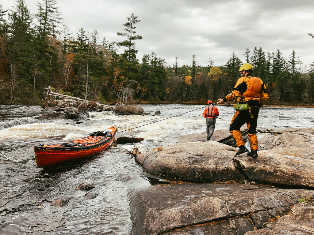
Lining the boat down a rapid on the Dumoine River.
Moisie River
The Moisie River is often called the ‘Nahanni of the East’, offering experienced whitewater paddlers an opportunity to tackle technical, high volume rapids in a beautiful, remote environment.
Getting to the Moisie River
The river begins at Lac DeMilles, near Labrador City and along the border between Quebec and Labrador. Despite its remoteness, the river is surprisingly accessible. Highway 500 cuts right by the lake and can be accessed from Quebec City via Highway 389. From Lac DeMilles, the river flows 440 km south to Sept-Îles, emptying into the St Lawrence River.
Moisie River Canoe Route
The Moisie River requires approximately two to three weeks to paddle. Over 440 km, there are dozens of rapids, including several Class III rapids and a handful of waterfalls and canyons to portage around.
From Lac DeMille, there are 100 km of lakes to paddle through before arriving at Lac Felix. The next section has a series of waterfalls, requiring several long portages to bypass. Following the Pékans / Moisie Confluence is another section of waterfalls and canyons, requiring portaging and technical paddling. From this point until Sept-Îles, the river calms down… somewhat. While the waterfalls may be behind you, there are still dozens of Class I-III rapids to paddle/portage.
All this to say, the Moisie River is one of the most exciting canoe routes in Canada. It does, however, require exceptional whitewater skills. Between the put in and the takeout, the river can only be accessed by float plane or helicopter.
Canoe Routes in Western Canada
Manitoba-Ontario Border
There are several provincial parks and crown land areas along the border and Manitoba and Ontario with fantastic canoe camping. There are hundreds, maybe thousands, of lakes scattered across the region. The topography is that of classic boreal forest - granite Canadian Shield, dark water, pine trees. Although recognized for its beauty, canoe routes around the Manitoba-Ontario border aren’t nearly as popular as canoe routes in southern Ontario.
Getting Here & Canoe Routes
Whiteshell Provincial Park is just north of Highway 17 and a short drive east of Winnipeg. There are several possible canoe trips in the area, especially if you cross into Ontario. Big Whiteshell Lake is a common place to launch a canoe trip. From there, you could paddle to Crowduck Lake, Eaglenest Lake, Echo Lake and Saddle Lake before looping back into Crowduck Lake.
Nopiming Provincial Park lies a little north, accessed via Provincial Road 314. This is a large park with hundreds of lakes and plenty of canoe route possibilities. Tulabi Falls and David Lake are popular access points.
Woodland Caribou Provincial Park and Atikaki Provincial Park - Woodland Caribou Provincial Park is a premier wilderness park entirely in Ontario, however, I’ve included it in this section because of its adjacency to Atikaki Provincial Park, which is entirely in Manitoba.
The Bloodvein River is a canoe trip on almost any whitewater paddler’s bucket list. Red Lake, in Woodland Caribou PP, is the headwaters to the Bloodvein. The river crosses Woodland Caribou and then flows across Atikaki Provincial Park. The Bloodvein is a total of 340 km, though you can skip some flatwater by flying into Artery Lake and starting from there, cutting the trip to 225 km. The Bloodvein is known for its rushing whitewater and waterfalls, beautiful boreal scenery and the presence of pictographs.

A pitstop on the river in the Manitoba area.
Seal River
The Seal River is a Canadian Heritage River in northern Manitoba. It begins in Shethanei Lake and travels 260 km to Hudson Bay, a little north of Churchill. The river offers a landscape unlike most of the other routes on this list; it passes through the transition zone between boreal forest and sub-arctic tundra
If you like reading about canoe trips in Canada, I strongly recommend reading River of Fire by Hap Wilson. He and three other men paddled the Seal River in the 1980s during one of Manitoba’s worst wildfire seasons. It’s an enthralling read.
Getting to the Seal River & Canoe Routes
The best way to access the Seal River is by flying to Tadoule Lake, a First Nation community of the Sayisi Dene people. From Tadoule Lake, you can paddle to Shethanei Lake and kick off your Seal River adventure.
After Shethanei Lake, there aren’t any opportunities to leave the river until you approach Hudson Bay. From here, you can take a float plane or boat shuttle to Churchill. The entire journey takes about two-three weeks to paddle.

Photo Credit: Ted Baird. Ted paddled the Seal River in 2021 over 25 days. You can watch his trip in his docu-series on Youtube: 25 Days Wild Camping in Northern Wilderness.
Bowron Lakes Circuit
The Bowron Lakes Circuit is a parallelogram of interconnected lakes in the interior of British Columbia. This canoe route offers a different experience than most of the other canoe routes on this list: the Bowron Lakes Circuit will have you paddle on glacial lakes in the shadow of the Rocky Mountains. There are 12 lakes along the 116 km route, with 50 campgrounds dispersed throughout the lakes.
Due to its popularity, only 27 canoes (or 54 people) are allowed to start the circuit each day.
Getting to the Bowron Lakes Circuit
Prince George is the nearest city to Bowron Lakes Provincial Park. Heading south from Prince George, you’ll have a two hour drive on the Willow Cale Forest Service Road before arriving at the park’s campground. From here, you can either do the Bowron Lakes Circuit clockwise or counterclockwise.
Bowron Lakes Circuit Canoe Route
To avoid extra long days, the circuit requires a minimum of five days to complete. Six or seven days is an ideal length to ensure you have enough time to savour each lake and maybe take a rest day in the middle. Moving counterclockwise, after Bowron Lake you would paddle southwest through Swan and Spectacle lakes before arriving at Sandy Lake. After making a nearly right turn, the next section goes east through Lanezi Lake. Shortly after, you’ll arrive at Isaac Lake, which is shaped like a huge L and eventually brings you back to Bowron Lake.

Bright skies ahead on the Bowron Lakes Circuit in British Columbia.
Canoe Trip in the Maritimes
Kejimkujik National Park
The Maritimes are better known for backpacking and sea kayaking, however there are a few places for excellent canoe tripping. One such place is Kejimkujik, a national park in the centre of Nova Scotia.
Getting to Kejimkujik National Park
Kejimkujik is accessed from Highway 8, which cuts through the centre of Nova Scotia southwest of Halifax. After turning off the highway, you can follow Kejimkujik Main Parkway to reach the different access points. The most popular access point is on Kejimkujik Lake. In addition to the access points, there are also campgrounds and outfitters here.
Kejimkujik Canoe Routes
Mersey River: Starting at Keji Lake, this route travels south to Low Landing via the Mersey River. Low Landing is the takeout on Lake Rossignol, the largest lake in the area and just outside the park.
Big Dam Lake to Keji Lake via Frozen Ocean Lake: This route begins at the access point on Big Dam Lake. From there, it travels along a narrow river to Frozen Ocean Lake. A few portages later, you’ll arrive at Keji Lake and can cross this large lake to the takeout at Jake’s Landing.
Canoe Trips in the Territories
Some of Canada’s best canoe trips are in Nunavut, Yukon and The Northwest Territories. Canoeing in the arctic isn’t easy or cheap, but the spectacular scenery and wildlife viewing make the effort well worth it.
Due to the remoteness, novice and intermediate paddlers will want to join a guided trip if paddling in the territories. Experienced paddlers can do self-guided trips, though they should have wilderness medicine and rescue experience.
Nahanni River
No list of canoe trips in Canada would be complete without the Nahanni River, perhaps Canada’s most iconic and sought after river. Nahanni National Park protects 30,000 sq km of the MacKenzie Mountains in the Northwest Territories, through which the Nahanni flows. Notable features along the river include Virginia Falls, which is considered North America’s most spectacular undeveloped waterfall, and the ‘Grand Canyons’, a series of four canyons the river cuts through.
Yukon River
Most of the rivers on this list are whitewater rivers, though if you’d prefer something slower pace, consider the Yukon River. The source of the Yukon River is in northern British Columbia; it then flows through Yukon and Alaska, eventually emptying into the Bering Sea. Unless you have two to three months to paddle the entire ~3,100 km, you’ll only be paddling a section. The section between Lac Laberge and Dawson City is a popular two-week trip, paddling 730 km through
Coppermine River
The Coppermine River begins near the border between Nunavut and The Northwest Territories. It flows north for over 800 km, emptying into the Arctic Ocean at the town of Kugluktuk. The river is known for its towering canyons and mountains, and its raging, bright blue water. It’s not uncommon to see muskox, caribou, grizzlers, moose and bald eagles. This is a remote and exciting river for experienced whitewater paddlers. For the less experienced, there are a few guiding companies that run canoe and rafting trips on the river.

Paddling a calm stretch of the Nahanni River, the most iconic canoe trip in Canada.
Other Canoe Trips in Canada of Note
For brevity’s sake, this list does not contain every single incredible canoe trip in Canada. That said, here are a few additional canoe trips worth exploring.
- Quetico (Ontario)
- Wabakimi (Ontario)
- Broadback River (Quebec)
- Fond du Lac (Saskatchewan)
- Spanish River (Ontario)
- Hayes River (Manitoba)
- Horton River (Northwest Territories)
I hope you’ve found some inspiration and are ready to start planning your next canoe trip in Canada!
Mikaela is the voice behind Voyageur Tripper, an outdoor blog that aims to teach people how to take longer and more challenging trips in the backcountry. She previously worked as a wilderness guide, leading canoeing and hiking trips in Ontario, Quebec and Nunavut. Mikaela currently lives on the West Coast. You can find her on Instagram at @voyageurtripper.


