


The Alabama Scenic River Trail: 631 Miles of Adventure on the Water

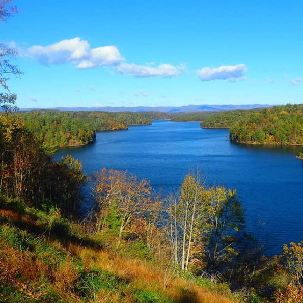
Shards of afternoon sunlight stream between the clouds scattered above Philpott Lake, making the water glisten. As I paddle away from the Twin Ridge Recreation Area, my tiny kayak is the only disturbance to the lake’s still surface. Water spreads in every direction as the lake splinters into slender branches, fringed by mixed hardwood forests spiced with maple, hickory, cedar, and pine. Beneath my boat, the reflection of clouds spread over the glassy water, an image so vivid it seems as if land and sky have traded places.
I’m exploring one of Virginia’s most pristine paddling destinations—and one of the Blue Ridge’s best-kept secrets—Philpott Lake. A sanctuary of serenity stretching into Franklin, Henry, and Patrick counties, the 3,000-acre lake was created more than a half-century ago, part of a government effort to prevent flooding and provide hydropower. Following bouts of severe flooding throughout the first half of the 20th century, including a flood on the Smith River in 1937 that put the town of Bassett underwater, Congress authorized the construction of the Philpott Dam in 1944. The Army Corps of Engineers set to work on the dam in 1948, and both dam and powerhouse were completed in 1953, making 2018 the 65th anniversary of the creation of Philpott Lake.
Although manmade, the landscape surrounding Philpott Lake remains wild and pristine. The lake’s 100-mile shoreline is engulfed by approximately 20,000 acres of protected federal and state lands, providing paddlers easy access to an utterly tranquil escape. On the lake, paddlers can explore miles of water cradled by hardwood forests and billowy foothills, while the shadowy peaks of the Blue Ridge cast a silhouette against the horizon.
Paddler’s Paradise

The clouds part as I approach Deer Island, sunlight lacquering the towering pines. In the distance, sandy beaches spread along the lakeshore, part of the Salthouse Branch Recreation Area. I stop paddling and let my kayak drift ashore. The shallow water surrounding Deer Island is crystalline, and I can see the mosaic of colorful pebbles spread over the bottom of the lake as my kayak hits land.
The idyllic Blue Ridge backdrop and blissful serenity have made Philpott Lake a paddler’s paradise for decades. But these days, the recently completed Philpott Lake Blueway makes the lake even more appealing—and accessible. The result of a partnership between several federal and local organizations, including the Army Corps of Engineers and the Dan River Basin Association, the Philpott Lake Blueway links boat launches and points of interest to create an epic paddling route that offers 25 miles to explore. Featuring nine different access points, all marked with informational signage, the water trail also links nine points of interest, including both natural wonders and historic locations providing a glimpse into the region’s rich history.
Back on the water, I spot the only other soul I’ve seen all day—a swift-swimming cormorant. I pause to watch the inky-black bird disappear beneath the surface, only to pop up unexpectedly a few feet away. A mechanically efficient swimmer, the seal-like waterbird leaves a slender line of wake on the surface of the water, and I follow his trail, continuing along one of most beautiful paddling routes I’ve ever kayaked.
The Blueway Sections
Ringing the entire lake, the Philpott Lake Blueway is actually made up of a series of bite-sized water trails, showcasing a collection of nearly a dozen scenic and historic highlights. There are nine distinct entry points, each with an interpretive kiosk and a proper entry point for watercraft. They include Philpott Marina, Bowens Creek, Goose Point, Salthouse Branch, Twin Ridge, Horseshoe Point, Jamison Mill, Ryans Branch, and Runnet Bag. The individual water trails range from 1.5 to 9 miles, and offer something for paddlers of all skill levels, providing options for everything from short-but-sweet day trips to epic overnight expeditions. Major points of interest along the blueway includes:
Philpott Dam: Besides generating hydropower and providing flood control, the 65-year-old Philpott Dam also created one of Virginia’s most beautiful bodies of water. Anchoring the southeastern corner of the lake, the dam is accessible from the Philpott Marina.
Bowens Creek Falls: Only accessible
Take a close look at the state seal of Alabama, and what do you see?
Water, and lots of it: a network of of creeks, streams, bayous, lakes, rivers, river delta, and oceanfront, all adding up to thousands of miles of paddling paradise for outdoor enthusiasts. Indeed, this web of waterways makes Alabama an amazing destination for kayakers, canoeists, stand-up paddleboarders, and even tube-toting folks out for a lazy summer float.
But for a truly memorable adventure, one paddling trip in particular stands out: the Alabama Scenic River Trail.
The ASRT is actually a nonprofit organization that began looking at maps and tracing those waterways. They realized that there was actually a route one could paddle from the Georgia state line in the mountains of northeast Alabama all the way to the Gulf of Mexico. It is a 631-mile float from mountain to sea that, according to the National Park Service, is the longest river trail in a single state.
It’s also overflowing with history: Along the way, you’ll get the chance to visit Native American sites and Civil War battlegrounds, explore serene backwater stretches without seeing another soul, and even paddle under the Edmund Pettis Bridge in Selma, one of the country’s most compelling civil rights landmarks. Another bonus? The route is easily accessible, with more than 100 points of river access and some 100 overnight campsites along way.
Whether you do a day paddle, a section, or the entire trail, you’re in for a real adventure on the Alabama Scenic River Trail. Here’s what to know.
The Path of the Paddle

Passing through Selma, the Alabama River flows beneath the Edmund Pettis Bridge, an infamous landmark of the Civil Rights movement. - Joe Cuhaj
A complete paddle of the trail from one end to the other takes about 48 days, depending on how fast you go. But, just as with land-based long-distance trails, you don’t have to tackle the entire length all in one shot. With the many campsites, launches, and parks along the route, not to mention outdoor outfitters and restaurants, it is easy to simply take a half- or full-day trip, or stretch your paddling adventure into an overnighter, weekend, or week-long (or longer) trip.
While the trail has numerous offshoots and tributaries, the main or "core" trail of the ASRT runs down two main rivers, the Coosa and Alabama, as well as through the second-largest river delta in the country, the Mobile-Tensaw Delta, and along the banks of historic Mobile Bay before finally ending in the Gulf of Mexico. The trail is divided into four sections: the Piedmont section,
from Centre, Alabama, to Childersburg; the Central section, from Childersburg to Wetumpka; the River Heritage section, from Wetumpka to Claiborne; and the Delta section, from Claiborne to Fort Morgan. Each of these stretches provides its own unique landscapes, wildlife, and challenges.
Historic Highlights, Raging Rapids, and America’s Amazon

The Coosa River is wide just before narrowing at the fast shoals and the class II/III whitewater of Moccasin Gap. - Lisa Panero
Purists will want to start the route right from its origin: three miles from the Georgia state line in the town of Cedar Bluff at the Riverside Campground and Motel. From here, the route winds down the Coosa River, past impressive rock bluffs and through wide, expansive lakes with miles of backwaters to explore.
As you move into what is known as the Central Section, you’ll begin to cross several other lakes, all of which were formed by dams now operated and maintained by the Alabama Power Company. Things can get a little tricky here, as you’ll have to portage around each of the dams, except for Mitchell Dam in Verbena which has a super steep bank. Here, it’s highly recommended to arrange a shuttle to take you around the dam.
Next up is the River Heritage section, which offers a taste of history and a little whitewater time. Just after Jordan Dam, the Coosa River has a series of fast-running shoals which is followed by the famous Moccasin Gap in the town of Wetumpka. During normal times, the Gap is a class II/III rapid, but in the summer the power company opens the flow of the dam, amping it up to a class IV.
Also in Wetumpka, at the convergence of the Tallapoosa and Coosa rivers to form the Alabama River, is Fort Toulouse-Fort Jackson. The original fort was established by the French in 1717 and marks the spot where the treaty that ended the Creek Indian War was signed in 1814.
A few miles farther downstream, you can dock your boat along the Riverwalk in the state capital, Montgomery, to check out the restaurants, shops, and nightlife. A little farther still, crossing into Selma, you’ll pass under the famous Edmund Pettis Bridge, the site of what is known as "Bloody Sunday" that occurred in 1965. Marchers of the Selma to Montgomery March were met with violence as they fought for their civil rights.
You will also encounter three more dams in this region, but thanks to agreements with the U.S. Army Corps of Engineers, there’s no need to portage: You can sit in your kayak and use the lock to continue downstream. (You’ll need to contact the lock before your arrival; phone numbers are available on the ASRT planning page.)

It’s important to know your way around The Mobile-Tensaw Delta while paddling. - Andrea Wright
From here, the Alabama River swings from an east-west flow to south as it heads into the Mobile-Tensaw Delta, which has been called "America’s Amazon" because of its rainforest-like environment. It’s a magical place to paddle, rich with wildlife, including alligators and wild boar, and trees draped with Spanish moss. But don’t get too distracted by your surroundings: Most of the trip through the delta is unmarked, and it is very easy to get lost in the thick forest and miles of narrow bayous. A good GPS is a must when paddling this section.
The last stretch of the trip skirts along the eastern shore of Mobile Bay, where you can visit the site of the last major battle of the Civil War at Historic Blakeley State Park and stroll along the Fairhope Pier, home to the excellent Shux on the Pier seafood restaurant. Wrap up your adventure at the tip of the Fort Morgan peninsula along the Gulf of Mexico, at the fort of the same name where the famous Battle of Mobile Bay took place during the Civil War.
If You Go
The ASRT provides an excellent online brochure full of information and resources to help plan your trip. And no matter how long your adventure on the trail, keep in mind the following:
-
Know how to use a map and compass and, of course, have them with you.
-
Carry a GPS with backup batteries.
-
Bring plenty of food and water and make sure to have extra in case of emergencies.
-
Remember, cell phones usually only work near cities.
-
Bring a change of clothes and keep them, and other important gear like cameras and cell phones, in a dry bag.
-
Bring an extra paddle.
-
Keep tabs on river stages and weather.
-
Once you reach the lower delta and Mobile Bay, tides can affect your trip, so plan accordingly.
-
Remember to pass through the locks on certain dams in the River Heritage section, you’ll need to make arrangements ahead of time. Phone numbers for the locks are available on the ASRT planning page.
-
Don’t forget a PFD.
Written by Joe Cuhaj for RootsRated
by paddle-craft, Bowens Creek Falls are tucked away in a secluded cove at the southern end of the lake. About a 30-minute paddle from the Bowens Creek launch site, the isolated falls don’t see many visitors, and during the summer the secluded spot is cooler than rest of the lake, offering a serene place to soak up the scenery.
Deer Island: Punctuating the southern portion of the lake, Deer Island is an especially enticing getaway for paddlers craving a multi-day outing. The scenic island is the largest on the lake, and it features paddle-in campsites, perfect for a night of relaxing after hooking one of Philpott Lake’s legendary largemouth bass. The island is easily accessible from the Goose Point and Salthouse Branch launch sites, and is just over a mile from the Philpott Marina.
Fairystone Lake Falls: Created when Goblintown Creek was dammed in the 1930s, the waters of Fairystone Falls spill into Philpott Lake near Fairystone State Park. When the creek was dammed to create Fairystone Lake, the town of Fayerdale was permanently flooded, and remnants of the historic mining community still remain beneath the surface of the water.
Jamison Mill: Named for the thriving mill built by Thomas Fleming in the late 1880s, Jamison Mill was operational until 1949, when the area was evacuated to create Philpott Lake. Although the historic mill is now underwater, Jamison Point makes for a picturesque picnic spot accessible only by boat.
Blue Falls: With the creation of Philpott Lake, the blue-tinged cliffs are all that remain of the Smith River’s historic Blue Falls. Paddlers can access the cliffs via a short paddle around the point under Union Bridge.
Calico Rocks: Soaring to a height of 200 feet, the cliff dubbed Calico Rock looms over the shoreline not far from Runnet Bag. Lucky for paddlers, the towering crag is best viewed from the water.
Emberson Falls: Tumbling down lichen-covered rocks, the waters of Emberson Falls flow into a small, rhododendron-fringed cove. The falls are only accessible by water, requiring a full day of paddling from either the Ryans Branch or Runnet Bag launch sites, and another 1.5 miles upstream, paddlers also hit White Falls.
Smith River/White Falls: Beginning as a small spring on the eastern slopes of the Blue Ridge Mountains, the Smith Rivers gains strength while winding through pristine swathes of forest and past historic farmlands. The waterway cascades over Black Falls and White Falls before slowing to form Philpott Lake.
Adjacent Adventures
A post shared by Dan River Basin Association (@danriverbasin)
You can transition from the still waters of Philpott Lake to the swift-moving Smith River, located just below Philpott Dam. The 7-mile section of river between Philpott Dam and Bassett takes paddlers past craggy hillsides covered with rhododendron and mountain laurel, providing class II rapids and plenty of opportunity to fish for brown, rainbow, or brook trout.
In Franklin County, the Pigg River Blueway offers paddlers another scenic paddle or float. Once a transportation lane for the county’s iron industry, today the 8-mile trip showcases leafy woodlands and pastoral farms. Expect to take about 4-5 hours to complete the route.
One of the oldest recreation areas in the state, Fairy Stone State Park is located just west of Philpott Lake, and features wooded trails for bikers, hikers, and runners, plus a 168-acre lake. The park also offers family-friendly campsites, lakeside cabins, and cozy yurts.
Trip Planning and Logistics
-
On the flatwater lake, paddlers moving at a leisurely pace should allow about 30 minutes per mile.
-
For paddlers craving a multi-day adventure, there are several campgrounds spread around Philpott Lake. The primitive campsites on Deer Island are available on a first-come, first-served basis, but lakeside campsites at the Salthouse Branch, Horseshoe Point, and Goose Point recreation areas can be reserved in advance. Some of the lake’s recreation areas are only open seasonally (from late spring to early fall), so be sure to check dates of operation before visiting.
-
For road-trippers cruising the iconic Blue Ridge Parkway, the Philpott Lake Blueway is easy to add to any adventure itinerary—the Philpott Lake Marina is located just 30 minutes from the parkway’s Rocky Knob Visitor Center (milepost 169).
-
Before hitting the water, pick up one of the handy Philpott Lake Blueway brochures (with map) at the lakeside Visitor Center managed by the Army Corps of Engineers.
Written by Malee Baker Oot for RootsRated Media in partnership with Visit Franklin County VA.


