


World-Class Canoeing in the Boundary Waters

The Boundary Waters Canoe Area Wilderness (BWCAW) was set aside in 1978 as part of Superior National Forest. It comprises about a million acres of forest, lakes and rivers in the Arrowhead Region of northeast Minnesota (the “arrow” formed between Lake Superior’s North Shore and Canada).
The northern border of the Boundary Waters is directly adjoined to Canada’s Quetico Provincial Park, adding another million-plus acres of wilderness canoe country.
(If you’re interested in the history of this area, click here.)
What Makes the Boundary Waters World-Class?
There are several reasons why canoeists have loved the BWCAW, and why many travel great distances to canoe here:
- The sheer size of the BWCAW with its 59 different entry points and 1,100 lakes offers 1,500 miles of trip route options. Go in for a day, a week—even several weeks—and you’ll never have to paddle the same lakes twice unless you want to.
- The pristine water quality of the lakes. The untouched forests. It’s true wilderness.
- 250,000 people a year visit the Boundary Waters, which is far fewer than the numbers you find in our national parks and more popular state parks. Spread them out over a million acres and there are times you may not see people aside from your own party for days.
- The Forest Service and Minnesota DNR enforce party size (limited to 9 people and 4 canoes at most), campsite use (camping is only allowed on designated sites) and motor use (only 19 lakes allow motors, almost all under 25hp). Wonderful solitude and tranquility.
- Diverse forests, sheer cliffs, rocky shorelines, waterfalls along many of the portages—everywhere you look there’s beauty.
- All 2,200 campsites are lakeside!

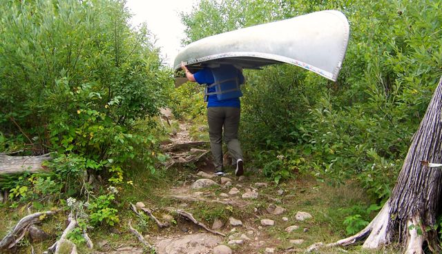
The World of Canoeing and Portaging
Personally, one of the things I love about canoe trips here is the combination of paddling and portaging. After sitting and working your upper body by paddling for a while, it feels great to get out and get your lower body moving on the portages. It’s very different than just canoeing or just backpacking.
It’s absolutely crucial to carry a BWCAW map with you that’s specific to your route, especially if you’ll be portaging (there are a couple different map publishers: Fisher Maps and McKenzie Maps). It’s a labyrinth out there, and sometimes you can’t see a portage until you’re almost on top of it. A map will show you not just the bays, inlets and islands but also the portages and campsites.
It’s also crucial to carry a compass, first aid kit and other common-sense safety items you’d take with you anytime you’re in the wilderness. There are no roads into the interior lakes and no cell phone service.
What Else is in the Boundary Waters?
Wildlife abounds here: black bear, moose, deer, fox, wolf, along with the smaller mammals. If you’ve never heard the haunting cry of the common loon (Minnesota’s state bird) it’s a sound you’re likely to hear here, and never forget. Water birds and raptors are abundant too, including bald eagles.
The lakes are loaded with northern pike, walleye, bass and perch, along with some pan fish. Fishing is a big draw for thousands of the BWCAW’s visitors each year.
As I mentioned, every campsite is a lakeside site. That can mean gorgeous sunrises and sunsets, plentiful water for drinking and cooking (bring purifying tablets or a good filter), great swimming or simply relaxing by the water. Each site has a fire pit with a grate and a pit toilet down a trail (that you’ll have to find—there are no signs, and make sure to bring your own TP!).
We’ve been to some campsites that are so gorgeous, we’ve planned future trips around them. It’s a joy to land on one of these that isn’t occupied (they’re all first-come-first-served) and be able to spend the night or even a few days.
If you plan your trip during most of July or early August keep a lookout for blueberries, serviceberries (Saskatoons) and raspberries. In many areas, the bushes are loaded both along portages and around campsites. They’re wonderful to snack on as you portage or save for your breakfast pancakes.
Who Uses the Boundary Waters?
In my times in the Boundary Waters I’ve seen parties of families, just men, just women, scouts, kids from camps or non-profit organizations, individuals—just about every combination imaginable.
There are two times I can remember being out there and running into someone we knew. On one trip I heard someone yell: “Sharon Brodin? Hi!” It was a former co-worker from Minneapolis! We exchanged greetings in the middle of Caribou Lake with her party canoeing east and my party canoeing west.
On another trip we were waiting for a group of kids to come off a portage so we could unload and head in. Suddenly we heard, “Aunt Krista?” My paddle partner’s nephew—from New Jersey—was one of the kids with this group from a nearby YMCA camp!

Those kinds of encounters are so fun, as is just chatting with complete strangers on the portages. I love hearing where folks are from and where their route is taking them.
What to Know about Canoeing in the Boundary Waters
Like any wilderness area you sometimes have to deal with bad weather—even dangerous weather. Be sure to check the forecast before heading out, bring quality rain gear, and prepare for low temps at night, even in the summer.
This is black bear country, so practice smart bear safety.
You’ll need a permit that includes a designated entry point and date, length of stay and number of people in your party.
Mid-June to mid-August is the busiest time, and some entrance points and lakes are more popular than others. If you want to plan your trip during these times you’ll want to plan ahead, especially if your dates aren’t flexible. Only a certain number of permits are issued each day per entry point.
Here are three private websites loaded with helpful information if you want to plan a canoe trip: CanoeCountry.com, PaddlePlanner.com and BWCA.com.
How to Get There
Most people go through either Ely or Grand Marais/The Gunflint Trail. There are dozens of quality outfitters in these areas that can set you up with just rental all the way to fully-guided trips. The three sites listed above all have links to outfitters.

A canoe trip in the Boundary Waters is a unique and unforgettable experience. I feel privileged to live just a half-day’s drive away so I can get there often.
I hope you’ll have a chance to get there someday, too!
(Photos courtesy of Sharon Brodin)
Questions? Give our Wisconsin-based customer service team a call or email today. We’re happy to help: (info)
More posts for you…


