


A Guide to Exploring Philpott Lake

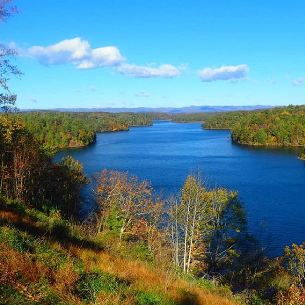
Shards of afternoon sunlight stream between the clouds scattered above Philpott Lake, making the water glisten. As I paddle away from the Twin Ridge Recreation Area, my tiny kayak is the only disturbance to the lake’s still surface. Water spreads in every direction as the lake splinters into slender branches, fringed by mixed hardwood forests spiced with maple, hickory, cedar, and pine. Beneath my boat, the reflection of clouds spread over the glassy water, an image so vivid it seems as if land and sky have traded places.
I’m exploring one of Virginia’s most pristine paddling destinations—and one of the Blue Ridge’s best-kept secrets—Philpott Lake. A sanctuary of serenity stretching into Franklin, Henry, and Patrick counties, the 3,000-acre lake was created more than a half-century ago, part of a government effort to prevent flooding and provide hydropower. Following bouts of severe flooding throughout the first half of the 20th century, including a flood on the Smith River in 1937 that put the town of Bassett underwater, Congress authorized the construction of the Philpott Dam in 1944. The Army Corps of Engineers set to work on the dam in 1948, and both dam and powerhouse were completed in 1953, making 2018 the 65th anniversary of the creation of Philpott Lake.
Although manmade, the landscape surrounding Philpott Lake remains wild and pristine. The lake’s 100-mile shoreline is engulfed by approximately 20,000 acres of protected federal and state lands, providing paddlers easy access to an utterly tranquil escape. On the lake, paddlers can explore miles of water cradled by hardwood forests and billowy foothills, while the shadowy peaks of the Blue Ridge cast a silhouette against the horizon.
Paddler’s Paradise

The clouds part as I approach Deer Island, sunlight lacquering the towering pines. In the distance, sandy beaches spread along the lakeshore, part of the Salthouse Branch Recreation Area. I stop paddling and let my kayak drift ashore. The shallow water surrounding Deer Island is crystalline, and I can see the mosaic of colorful pebbles spread over the bottom of the lake as my kayak hits land.
The idyllic Blue Ridge backdrop and blissful serenity have made Philpott Lake a paddler’s paradise for decades. But these days, the recently completed Philpott Lake Blueway makes the lake even more appealing—and accessible. The result of a partnership between several federal and local organizations, including the Army Corps of Engineers and the Dan River Basin Association, the Philpott Lake Blueway links boat launches and points of interest to create an epic paddling route that offers 25 miles to explore. Featuring nine different access points, all marked with informational signage, the water trail also links nine points of interest, including both natural wonders and historic locations providing a glimpse into the region’s rich history.
Back on the water, I spot the only other soul I’ve seen all day—a swift-swimming cormorant. I pause to watch the inky-black bird disappear beneath the surface, only to pop up unexpectedly a few feet away. A mechanically efficient swimmer, the seal-like waterbird leaves a slender line of wake on the surface of the water, and I follow his trail, continuing along one of most beautiful paddling routes I’ve ever kayaked.
The Blueway Sections
Ringing the entire lake, the Philpott Lake Blueway is actually made up of a series of bite-sized water trails, showcasing a collection of nearly a dozen scenic and historic highlights. There are nine distinct entry points, each with an interpretive kiosk and a proper entry point for watercraft. They include Philpott Marina, Bowens Creek, Goose Point, Salthouse Branch, Twin Ridge, Horseshoe Point, Jamison Mill, Ryans Branch, and Runnet Bag. The individual water trails range from 1.5 to 9 miles, and offer something for paddlers of all skill levels, providing options for everything from short-but-sweet day trips to epic overnight expeditions. Major points of interest along the blueway includes:
Philpott Dam: Besides generating hydropower and providing flood control, the 65-year-old Philpott Dam also created one of Virginia’s most beautiful bodies of water. Anchoring the southeastern corner of the lake, the dam is accessible from the Philpott Marina.
Bowens Creek Falls: Only accessible by paddle-craft, Bowens Creek Falls are tucked away in a secluded cove at the southern end of the lake. About a 30-minute paddle from the Bowens Creek launch site, the isolated falls don’t see many visitors, and during the summer the secluded spot is cooler than rest of the lake, offering a serene place to soak up the scenery.
Deer Island: Punctuating the southern portion of the lake, Deer Island is an especially enticing getaway for paddlers craving a multi-day outing. The scenic island is the largest on the lake, and it features paddle-in campsites, perfect for a night of relaxing after hooking one of Philpott Lake’s legendary largemouth bass. The island is easily accessible from the Goose Point and Salthouse Branch launch sites, and is just over a mile from the Philpott Marina.
Fairystone Lake Falls: Created when Goblintown Creek was dammed in the 1930s, the waters of Fairystone Falls spill into Philpott Lake near Fairystone State Park. When the creek was dammed to create Fairystone Lake, the town of Fayerdale was permanently flooded, and remnants of the historic mining community still remain beneath the surface of the water.
Jamison Mill: Named for the thriving mill built by Thomas Fleming in the late 1880s, Jamison Mill was operational until 1949, when the area was evacuated to create Philpott Lake. Although the historic mill is now underwater, Jamison Point makes for a picturesque picnic spot accessible only by boat.
Blue Falls: With the creation of Philpott Lake, the blue-tinged cliffs are all that remain of the Smith River’s historic Blue Falls. Paddlers can access the cliffs via a short paddle around the point under Union Bridge.
Calico Rocks: Soaring to a height of 200 feet, the cliff dubbed Calico Rock looms over the shoreline not far from Runnet Bag. Lucky for paddlers, the towering crag is best viewed from the water.
Emberson Falls: Tumbling down lichen-covered rocks, the waters of Emberson Falls flow into a small, rhododendron-fringed cove. The falls are only accessible by water, requiring a full day of paddling from either the Ryans Branch or Runnet Bag launch sites, and another 1.5 miles upstream, paddlers also hit White Falls.
Smith River/White Falls: Beginning as a small spring on the eastern slopes of the Blue Ridge Mountains, the Smith Rivers gains strength while winding through pristine swathes of forest and past historic farmlands. The waterway cascades over Black Falls and White Falls before slowing to form Philpott Lake.
Adjacent Adventures
A post shared by Dan River Basin Association (@danriverbasin)
You can transition from the still waters of Philpott Lake to the swift-moving Smith River, located just below Philpott Dam. The 7-mile section of river between Philpott Dam and Bassett takes paddlers past craggy hillsides covered with rhododendron and mountain laurel, providing class II rapids and plenty of opportunity to fish for brown, rainbow, or brook trout.
In Franklin County, the Pigg River Blueway offers paddlers another scenic paddle or float. Once a transportation lane for the county’s iron industry, today the 8-mile trip showcases leafy woodlands and pastoral farms. Expect to take about 4-5 hours to complete the route.
One of the oldest recreation areas in the state, Fairy Stone State Park is located just west of Philpott Lake, and features wooded trails for bikers, hikers, and runners, plus a 168-acre lake. The park also offers family-friendly campsites, lakeside cabins, and cozy yurts.
Trip Planning and Logistics
-
On the flatwater lake, paddlers moving at a leisurely pace should allow about 30 minutes per mile.
-
For paddlers craving a multi-day adventure, there are several campgrounds spread around Philpott Lake. The primitive campsites on Deer Island are available on a first-come, first-served basis, but lakeside campsites at the Salthouse Branch, Horseshoe Point, and Goose Point recreation areas can be reserved in advance. Some of the lake’s recreation areas are only open seasonally (from late spring to early fall), so be sure to check dates of operation before visiting.
-
For road-trippers cruising the iconic Blue Ridge Parkway, the Philpott Lake Blueway is easy to add to any adventure itinerary—the Philpott Lake Marina is located just 30 minutes from the parkway’s Rocky Knob Visitor Center (milepost 169).
-
Before hitting the water, pick up one of the handy Philpott Lake Blueway brochures (with map) at the lakeside Visitor Center managed by the Army Corps of Engineers.
Written by Malee Baker Oot for RootsRated Media in partnership with Visit Franklin County VA.


